Showing posts with label ethics. Show all posts

Sunday, June 17, 2012

Risks of Mapping Indigenous Lands, Ep 2 - Giacomo Rambaldi, CTA


Giacomo Rambaldi from CTA discusses participatory mapping including the benefits and risks during the "Participatory Mapping and Community Empowerment for Climate Change Adaptation, Planning and Advocacy workshop" held in Solomon Islands on 21-26 May 2012.

Video by TNC, Kat Gawlik

Saturday, April 23, 2011

Free, Prior and Informed Consent in REDD+

The principle that indigenous peoples and local communities have a right to give or withhold their Free, Prior, and Informed Consent (FPIC) to developments affecting their resources is not new. However, experience using FPIC in REDD+ implementation is still limited in the Asia-Pacific region. Using relevant examples from a range of locations and sectors, this manual provides a basis for developing country-specific guidance on employing FPIC in REDD+ processes. This new report has been published by The Center for People and Forests (RECOFTC) and the German Agency for International Cooperation (GIZ). The report is, according to the Introduction, “targeted at people concerned with the design and implementation of REDD+ projects or programs.”

RECOFTC and GIZ’s report can be downloaded here: “Free, Prior, and Informed Consent in REDD+: Principles and Approaches for Policy and Project Development” (1.4 MB)

Wednesday, November 10, 2010

Sacred Natural Sites: Conserving Nature and Culture

Edited by Bas Verschuuren, Robert Wild, Jeffrey McNeely and Gonzalo Oviedo

This book illustrates that sacred natural sites – the world’s oldest protected places – although often under threat, exist within and outside formally recognised protected areas and heritage sites. They may well be some of the last strongholds for building resilient networks of connected landscapes as well as forming important nodes for maintaining a dynamic cultural fabric in the face of global change.

The diverse authors bridge the gap between approaches to the conservation of cultural and biological diversity by taking into account cultural and spiritual values together with the socio-economic interests of the custodian communities and other relevant stakeholders.

Tuesday, June 01, 2010

Whose Map? | ¿De Quién Son Los Mapas? | à qui appartiennent les cartes ? English / français/ español

In recent years, changes in participatory methodologies (PMs) may have been even more rapid than those in spatial technologies. Local people's abilities to make maps only became widely known and facilitated in the early 1990s. In this article Dr. Robert Chambers argues that participatory mapping has spread like a pandemic with many variants and applications not only in natural resource management but also in many other domains. With mapping as one element, there are now signs of a new pluralist eclecticism and creativity in PMs. The medium and means of mapping, whether ground, paper or GIS and the style and mode of facilitation, influence who takes part, the nature of outcomes and power relationships. Much depends on the behaviour and attitudes of facilitators and who controls the process. Many ethical issues present troubling dilemmas, and lead to overarching questions about empowerment and ownership. Questions to be asked, again and again, are: Who is empowered and who disempowered? And, who gains and who loses?

Below is the original article published on  EJISDC, an open access journal, and translations in French and Spanish done in the context of the development of the "Training Kit on Participatory Spatial Information Managamant and Communication" soon to be published by CTA and IFAD.
Here is a related interview with Robert Chambers subtitled in 10 languages (you can embed this video on your blog or web site!)

Tuesday, February 23, 2010

Ethics are central to community-based mapping processes


Dr. Nigel Crawhall, Director of Secretariat at the Indigenous Peoples of Africa Coordinating Committee (IPACC), a pan-African network, elaborates on the value of ethics in the context of participatory mapping processes.

More on practical ethics in PPGIS/PGIS practice is found here.

Monday, February 08, 2010

Knowledge and cultural transmission in Kenyan participatory mapping


In this 5 minute interview Dr. Nigel Crawhall, Director of Secretariat at IPACC, elaborates on intergenerational ecological knowledge transmission in Participatory 3-dimensional modelling (P3DM). Crawhall discusses his observations on intergenerational interaction when the Ogiek community of Nessuit, Kenya built a geo-referenced model of their mountain forest landscape in 2006.

Friday, October 23, 2009

Dr. Robert Chambers elaborates on Participatory GIS (PGIS) practice


Dr. Robert Chambers from the Institute of Development Studies (IDS), UK, reflects on the intersection of participatory development and Geographic Information Systems (GIS) and on the resulting good and bad practices. In the interview Dr. Chambers calls on practitioners and development agencies to ensure that good practice is put in place to avoid the repetition of the misuse of PRA (i.e. Participatory Rural Appraisal) done in the 80's and 90's.

Monday, May 04, 2009

Participatory 3D Modelling in Bale, Ethiopia

MELCA Mahiber, an Ethiopian NGO member of the African Biodiversity network (ABN), facilitated the construction of a large Participatory 3D Model covering 1,575 sq. km (at a 1:12,500-scale) in Bale and West Arsi, Ethiopia.

The exercise has been done to assist local communities in planning out a more sustainable management of the area, reviving local bio-cultural diversity and supporting local environmental education.

More information on the exercise is found here.

Wednesday, January 14, 2009

2009 PGIS / PPGIS Photo Competition launched by CTA

The Technical Centre for Agricultural and Rural Cooperation ACP-EU (CTA) has launched a Photo Competition. Participants can win prices up to a maximum of EUR 900! CTA and partners are creating a multimedia multilingual training kit to support the spread of good participatory mapping practice. The training kit will promote examples of participatory mapping from around the Globe. A collection of images will be included in the photo library of the kit.

The competition has been launched to enrich the library with a wide variety of examples and applications from around the world. The competition allows development practitioners and researchers to share photographic records of their experiences with other peers and contribute to a product (the training kit) which will be freely available in different languages in 2010. More about the competition, its legal conditions, guidelines for submission and procedures of selection and awarding is found on the recently launched CTA web site dedicated to Participatory GIS (PGIS) practice.

Sunday, November 23, 2008

Innu Place Names Website

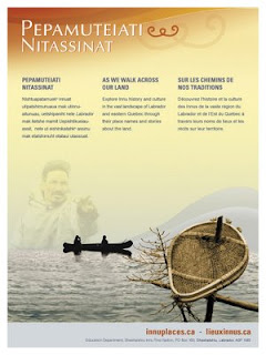
Labrador Innu launched the first comprehensive cultural website dedicated entirely to Aboriginal place names. Called Pepamuteiati nitassinat (‘As We Walk Across Our Land’), the website gives access to over 500 Innu place names in Labrador, as well as stories, photos, and video clips associated with the names. The website can be explored at http://www.innuplaces.ca/ . Innu Nation Grand Chief, Mark Nui, said, “Place names are very important to our people because they are a gateway to our history on the land. Many younger Innu who have gone through the provincial educational system have never learned these names. We hope that the website will help them learn about their culture and history.”

Lots of place names in Labrador come from the Innu (e.g. Minipi-Lake from Minai-nipi,
meaning ‘burbot lake’), but others were given by pilots, mining companies, settlers and outfitters and were imposed on places that already had Innu names. The website will enable the Innu and members of the general public to start using the Innu place names, to learn about the meaning of the names and how to pronounce them.

Other Aboriginal groups have been doing place name research over the years, and some are in the process of publishing their own websites (e.g. James Bay Cree and Norwegian Sámi). However, Pepamuteiati nitassinat is the first, comprehensive one put on line to date.

Grand Chief Nui pointed out that “Over thirty years of research with our Elders went in to this website. It’s a gift from our Elders to younger Innu people. It’s part of our Elders’ legacy. It’s also an important part of our intangible cultural heritage that will help educate people about the richness of our history and traditions.”

The website was made possible by contributions from many institutions and agencies including multimedia company Idéeclic, Environment Canada, Parks Canada, Memorial University Linguistics, and Canadian Boreal Trust. The Innu Nation wishes to acknowledge the generous financial support of the Department of Canadian Heritage through Canadian Culture Online.

History of the website project

  • The Innu place names available on the website were collected in the context of a number of research projects going back to the mid-1970s.
  • The biggest source of place names for the site is a 1980 mapping project. Over 500 maps at 1:50,000 scale were cut and taped together to form two giant maps. One was laid on the gym floor at Peenamin McKenzie School in Sheshatshiu and the other in the parish hall in the former community of Davis Inlet. Older hunters were invited to walk about on these maps to point out the locations of place names as well as old travel routes, camp sites, caches, birth places and good hunting and fishing places.
  • Only seven of the 34 older hunters who worked on the 1980 mapping project are still living.
  • A great deal of validation work was undertaken with respect to the places names which was done by ethnolinguist, José Mailhot, and anthropologist Peter Armitage, with the collaboration of Marguerite MacKenzie, Sebastien Piwas, George Gregoire, Jean-Pierre Ashini, Basile Penashue, Tony Penashue, and several Innu Elders.
  • Project managers for the website project were Kanani Penashue and Peter Armitage.

What’s on the website

  • The site features a searchable database of over 500 Innu place names.
  • Each place name record in the database contains information about the meaning of the name, how to pronounce it, and its location. Site users can click on an audio icon to hear the pronunciation of each place name.
  • The site has an interactive map showing the locations of the place names.
  • Background information on how Innu place names are constructed is presented.
  • Video clips and photographs show people what the named places look like or document land use activities there.
  • Audio narratives from Innu Elders and youth tell stories about events and people associated with certain place names.
  • Future phases of the website will add more place names, video clips, photos, and audio stories.

Source: Press relase by Natuashish (Labrador), 21.11.08

Saturday, September 06, 2008

Information and Communication Technology and Peacebuilding: Summary of a Workshop

Those who would use information and communication technology (ICT) in the cause of peace need to be cognizant of the risks as well as the benefits. ICT can facilitate positive dialogue but also hate speech. It can be used to fight corruption but also facilitate it. Simply giving people more information does not necessarily lead to predictable or positive results. As people become more informed, they may become more motivated to change their circumstances and to do so violently.

On December 14, 2007, the National Academy of Engineering (NAE) convened a group of experts in diverse fields to consider the role of ICT in promoting peace and conflict resolution. The one-day workshop was designed to consider current and emerging technologies and strategies for employing them in conflict management and diplomacy. Giacomo Rambaldi presented a case study on "GIS and Participatory 3-D Modeling in Land-Use Negotiation" . The workshop also aimed to explore how organizations with a role in promoting peace, like the U.S. Institute of Peace, can most effectively leverage technology in carrying out their missions.

"Information and Communication Technology and Peacebuilding: Summary of a Workshop" reviews the group's discussions on number of key issues, illuminates certain practitioner needs, and suggests possible next steps.

The proceedings can be downloaded for free via this link.

Tuesday, August 26, 2008

African Indigenous Peoples’ Workshop on effective use of ICTs in environmental advocacy

Starting on August 26, 2008 IPACC is holding a 3 day workshop outside of Windhoek Namibia for 40 indigenous African leaders to review case studies of how geo-spatial information technologies can be used by indigenous peoples to express their traditional ecological knowledge to decisions makers for the purposes of securing recognition and rights. The workshop will also look at the role of the internet (Web 2.0) in helping promote good advocacy and communication. The event is co-hosted and presented by the Technical Centre for Agricultural and Rural Cooperation (CTA), the Rainforest Foundation UK, ERMIS Africa, Cybertracker Conservation and Shalin Ry.

Tuesday, July 08, 2008

Ethics and Anthropological Research and Practice

In this concise introduction to anthropological ethics, Whiteford and Trotter provide current and prospective researchers and practitioners with a solid foundation of ethical concepts and issues, including respect for persons, beneficence, and justice. They take into account both national and international discussions and practice of ethics. Together with equipping readers with essentials about ethics, the authors explore ethical problems common among anthropologists. Ethical challenges often arise from the unanticipated consequences of a research design, from conflicts among stakeholders, or from the clash of two positive ethical principles--when adherence to one of the principles may violate another. Functioning both as a capstone and a learning tool, the last chapter presents a real-life ethical dilemma and introduces readers to a detailed problem-solving guide. Other pedagogical aids include end-of-chapter questions that inspire deeper thinking about ethical principles, issues, and considerations, and five brief ethical dilemma cases for further enrichment and study. In this concise introduction to anthropological ethics, Whiteford and Trotter provide current and prospective researchers and practitioners with a solid foundation of ethical concepts and issues, including respect for persons, beneficence, and justice. They take into account both national and international discussions and practice of ethics. Together with equipping readers with essentials about ethics, the authors explore ethical problems common among anthropologists. Ethical challenges often arise from the unanticipated consequences of a research design, from conflicts among stakeholders, or from the clash of two positive ethical principles--when adherence to one of the principles may violate another. Functioning both as a capstone and a learning tool, the last chapter presents a real-life ethical dilemma and introduces readers to a detailed problem-solving guide. Other pedagogical aids include end-of-chapter questions that inspire deeper thinking about ethical principles, issues, and considerations, and five brief ethical dilemma cases for further enrichment and study.

Friday, June 06, 2008

PGIS Curriculum Development Workshop

On 21 and 22 April 2008, CTA hosted a “Curriculum Development Workshop” as part of the project known as “Support the spread of good practice in generating, managing, analysing and communication spatial information”. The event brought together 35 people from different continents (Africa, Asia, Latin America, Northern America and Europe), all sharing a solid experience in participatory mapping and communication. The aim of the workshop was to kick-start the process which would lead to the production of a multilingual, multimedia and modular training kit on ‘Participatory Spatial Information Management and Communication”.

The output of the initiative is intended to increase the capacity of indigenous and other marginalised peoples to engage in effective policy dialogue and advocacy on issues related to the territory. Skills acquired through the deployment of the kit would ensure that indigenous and other marginalised communities are more effective in documenting, representing and communicating their spatial knowledge, while taking a high degree of control over the processes. The initiative is co-funded by CTA and IFAD. Development partners which committed additional resources to the project include the Indigenous Peoples of Africa Coordinating Committee (IPACC); International Institute for Geo-Information Science and Earth Observation (ITC), the University of British Columbia, Okanagan (UBC), UNOSAT and the Ford Foundation Brazil.

The direct beneficiaries of the project are technology intermediaries working in multidisciplinary teams and operating within institutions or organisations already committed to practicing participatory mapping and who are or would be required to deliver training on the practice, or facilitate the process in the field. Ultimate beneficiaries will be adopters from community-based organisations, non-governmental organisations, research institutions, academia, multilateral and bilateral development agencies and other development actors.

The English version of the kit is expected to be available in 2009 followed by versions in other languages.

Wednesday, May 21, 2008

Participatory Ethics - Special Thematic Issue of ACME

Vol 6 (3) of ACME (an International E-Journal for Critical Geographies) is dedicated to Participatory ethics. The 10 papers making up the issue are of interest to PGIS/PPGIS practitioners and researchers.